Space is a constant source of wonder and contemplation. Full of stars, moons, planets, cosmic rays, and magnetic fields, what’s “up there” can change the way we look at what’s “down here” on Earth — and, perhaps, remind us how different things can look when we zoom out.
The below images do just that: They capture 15 iconic locations — including the Pyramids of Giza, the Great Barrier Reef, and the Grand Canyon — from the distinctly distant perspective of space. Rather than the massive structures we know them as, the landmarks appear as dots, specks, swirls, and lines.
While many of the shots were taken with powerful lenses and enhanced with technology, a few of the landmarks can reportedly be seen from space with the naked eye. Either way, these images allow us to observe our planet from a new view that can make everything seem bigger or smaller, depending on how you look at it.
Great Barrier Reef | Australia
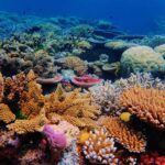
With about 3,000 individual coral reefs that extend over 1,400 miles, the Great Barrier Reef is the largest reef system on Earth. According to NASA, the reef is also “easy to spot” from space as the “iridescent blues of shallow lagoons contrast sharply with the dark blues of deep water.”
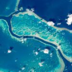
The above photo was snapped Oct. 12, 2015 by an astronaut aboard the ISS using a powerful lens.
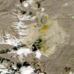
The Grand Canyon | Arizona
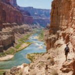
The Grand Canyon in northern Arizona is 277 miles long, up to 18 miles wide, and 1 mile deep. And it’s a popular tourist attraction not only for people here on Earth, but also those up in space. NASA reports that astronauts often take pictures of the Grand Canyon from the ISS, showing the depth and size of the familiar canyon from an unfamiliar perspective (about 250 miles above sea level).
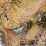
Through a partnership with NASA, the National Park Service, and the USGS, take a “fly-through animation” of the Grand Canyon, which includes images from space.
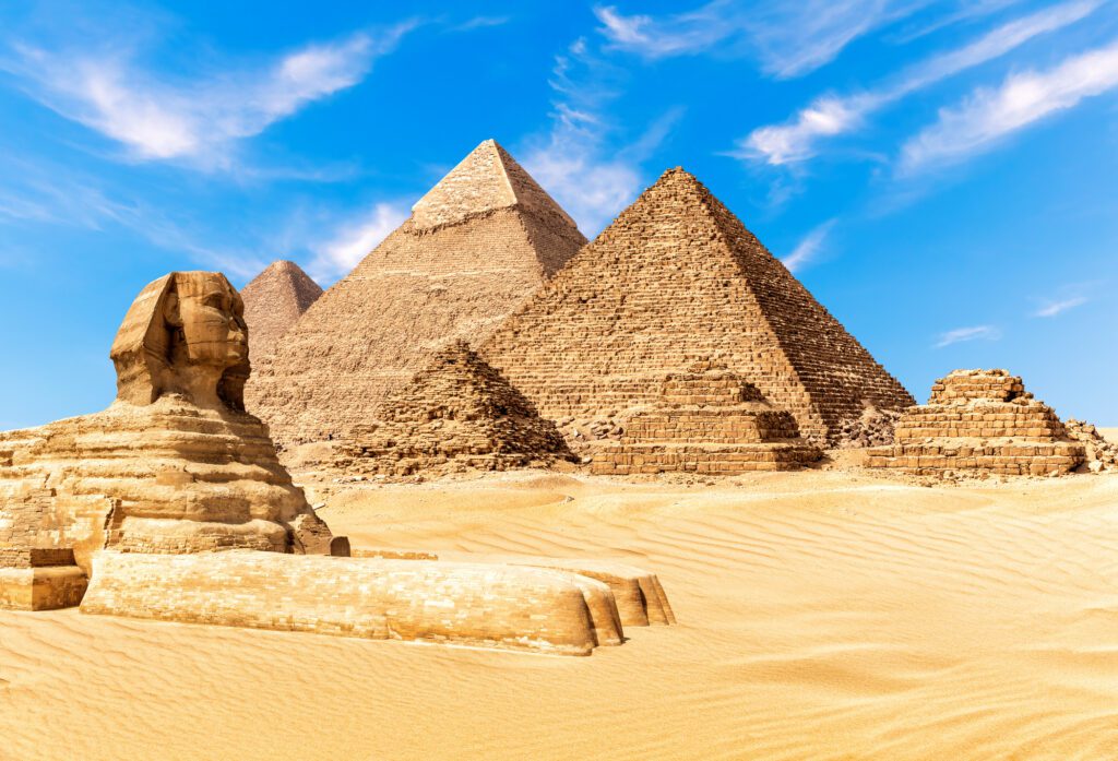
The Pyramids of Giza | Egypt
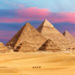
The three Pyramids of Giza are among of the world’s most iconic landmarks: Brittanica described Khufu’s pyramid as “perhaps the most colossal single building ever erected on the planet,” and one astronaut reported seeing the massive structures with the naked eye from outer space.
“There is much that can be seen from the [International Space Station, or ISS], even with the naked eye,” Leroy Chiao, a former NASA astronaut and ISS commander, told Live Science. “For example, I once found the great pyramids with a telephoto, and I could pick the two big ones out with the naked eye — so long as the lighting and weather conditions were good — as two tiny dots.”
However, another astronaut, Tim Peake, suggested that while the Great Pyramids of Giza cannot be seen with the naked eye, they can be viewed relatively clearly through an 800 mm lens. Despite their differing perspectives, they can likely agree on one things: Giza’s pyramids are rich with mystery.
Three Gorges Dam | China
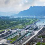
Built along China’s Yangtze River, the Three Gorges Dam is more than 1.4 miles long, about 594 feet tall, and known to be the largest hydroelectric facility in the world. “In 2012, it became the world’s largest hydroelectric power plant, with a generating capacity of 22,500 megawatts, over three times that of the Grand Coulee Dam and 20 times that of Hoover Dam,” per the U.S. Geological Survey.
According to NASA, it is “one of the few man-made structures so enormous that it’s actually visible to the naked eye from space.”
Palm Islands | Dubai
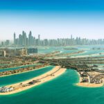
Dubai’s human-made Palm Islands are among the largest artificial islands in the world and can be seen from space, as observed in the below image captured by NASA’s Terra satellite on Sept. 18, 2006.
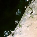
About four years later, in a 2010 edition of The New York Times, an image was released showing the palm tree-like formation of the islands, along with the nearby “300 private man-made islands shaped like a global map.”
The Amazon River | Brazil
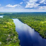
There’s been a long-running debate about which river is longer: the Amazon or the Nile? Regardless of which one takes the top spot, there’s no question that the Amazon is enormous at about 4,000 miles long.
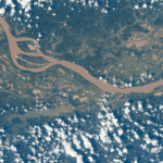
Weaving through the rainforest, the river can be seen from the ISS, which orbited 260 miles above Brazil in South America on Dec. 23, 2020.
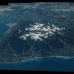
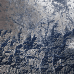
The Himalayas | Asia
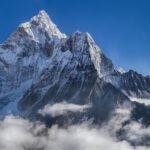
The snow-capped Himalayas, which span the Asian continent and rise up to 29,000 feet, are so immense they can be seen in striking formation from space.
And from a different angle, this image of Mount Everest captured from space makes Earth’s tallest mountain above sea level look about the size of a fingernail.
Crater Lake | Oregon
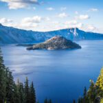
Known for its rich blue color, the main attraction in Oregon’s Crater Lake National Park is set in a dormant volcanic basin — as seen in the below 2017 image from the International Space Station.
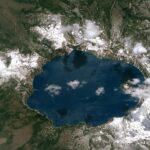
In addition to the vivid lake, snow is seen blanketing the slopes, along with shadows from clouds on the water’s surface.
Yellowstone National Park | Wyoming
Another example of national parks seen from high above, the below 1996 photo shows Yellowstone National Park in Wyoming and Montana, which stretches about 3,500 square miles.
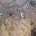
According to the Universities Space Research Association, Jackson Lake and the Grand Teton Mountains (outside the park) are at the extreme left, while Yellowstone Lake is at center left.
Bingham Canyon Mine | Utah
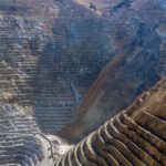
Located southwest of Salt Lake City, Utah, the Bingham Canyon Mine — also known as Kennecott Copper Mine — is so enormous it can be seen as little curved lines in the satellite image below.
According to the National History Museum of Utah, the mine has produced more copper than any mine in history — about 19 million tons — and it is about 2.75 miles wide at the top and 0.75 miles deep.
Olympic National Park | Washington
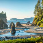
Astronaut Jeff Williams captured a series of stunning photos of Olympic National Park in Washington during his Expedition 47/48 mission aboard the ISS, and the shots were then assembled into the composite image below.
According to NASA, the park “encompasses nearly 923,000 acres of wild lands, including 60 named glaciers, 73 miles of coast, and 3,000 miles of rivers and streams.”
Lake Oahe | South Dakota
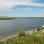
Lake Oahe in South Dakota — the fourth largest human-made reservoir in North America — was photographed by an astronaut looking down from the ISS on June 25, 2019. The image, captured with a 116 mm lens, also highlights the importance of agriculture to the state.
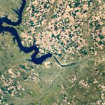
“The extensive rectangular fields around the river and lake are a visual reminder that agriculture is the main economic engine of the state,” explained NASA, noting that the image was “cropped and enhanced to improve contrast.”
Paris at Night | France
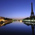
The “City of Light” lives up to its name in the below photograph taken by astronauts around midnight on April 8, 2015 using a 400 mm lens.
While many cities can be at night from space, Paris is particularly iconic due to its winding street grid and the bright boulevard of Avenue des Champs-Élysées.
The Great Wall of China | China
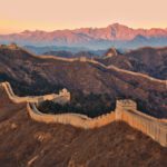
The Great Wall of China, along with Inner Mongolia, is featured in the below image taken by Expedition 10 Commander Leroy Chiao on the ISS.
Contrary to myths that the wall is visible from the moon, NASA assures it is not, further explaining that it is also “difficult or impossible to see from Earth orbit without the high-powered lenses used for this photo.”
Earth

Last but not least, we’d be remiss if we didn’t include Earth on this list of space images. While our planet isn’t a traditional landmark, it is a powerful, awe-inspiring sight to see from space. In fact, there’s even a term for the experience: the Overview Effect.
The term — coined by author and space philosopher Frank White — is used to articulate the “cognitive shift” and renewed sense of togetherness when one looks at Earth as a whole from outer space.
White told NASA: “We may have different religions, we may have different politics. But ultimately, we are connected. Totally connected. And not only with people, but with life. We’re totally connected with life. And everything relates to everything else.”
RELATED: “Made Me Fall Off My Chair”: Scientists Saw a Star Swallow a Planet for the First Time


Pingback: Angthong National Marine Park
Pingback: ต่อผมแท้
Pingback: ตอบคอมเม้น Facebook อัตโนมัติ